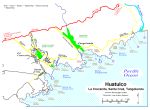
Home >> Oaxaca >> Huatulco >> Beaches of Huatulco

The Beaches of Huatulco, Oaxaca

The rugged terrain of the area divides the coastline into numerous isolated bays (bahías) and beaches (playas). I will group the beaches into the areas of Santa Cruz, Tangolunda, Bahía Conejos, and the area west of Santa Cruz. You may wish to refer to the Map of Huatulco or a regional map of the Oaxacan Coast (East). Also, please refer to the scuba section for an important note on the variability of wave strength due to phases of the moon.

Main IndexBeach Index
Huatulco, Oaxaca
Bahías de Huatulco
Huatulco Airport
Scuba Diving
Snorkeling Basics
Fishing in Huatulco
Fish of the Oaxacan Coast
Map
Visitors' Comments
AboutHomeSearch

Santa Cruz area Beaches

Playa La Entrega (the surrender) • This beach is where the Italian sailor Francisco Picaluga betrayed General Vicente Guerrero. The 600' beach is the southernmost of the Santa Cruz beaches and is good for swimming and diving. Wave action varies from calm to moderate at different places along the beach. Accessible by land and boat.

Playa Yerbabuena (mint) • This small, quiet beach is located on the western shore of Bahía de Santa Cruz, north of Playa La Entrega. Accessible by boat. Moderate waves.

Playa Santa Cruz (cross) • Located in Santa Cruz, this 800' long beach features calm waters, coral, sea shells, and lots of fish life. A good place to snorkel or scuba, but watch out for sea urchins and moray eels. Small underwater cave. Restaurants, equipment rental, and boat rides available. See Aerial Photos.

Playa Chahue 2000' long, sloping beach with moderate waves located east of Santa Cruz. For experienced swimmers.

Playa Esperanza (hope) • 400' long, strong waves, east of Playa Chahue. Not recommended for inexperienced swimmers.

Playa El Tejón (badger) • 400' long with moderate waves, located east of Playa Esperanza.


Tangolunda Beaches

Playa Consuelo (consolation) • A small, 250' beach with moderate waves west of Bahía Tangolunda. Accessed by boat.

Playa El Arrocito • A small, 300' beach with small waves and shallow depth located just west of Bahía Tangolunda. Accessed by boat.

Playa Ventura, Playa La Manzanilla (camomile), & Playa Tornillo (bolt) • These three beaches are located together on the western shore of Bahía Tangolunda at the Club Med. They total about 600' in length with calm waves. Good for swimming, snorkeling and all aquatic sports.

Playa Tangolunda The Sheraton, the Maeva, and the golf course are located on this 1/2-mile long beach. The beach may also be accessed through Tangolunda Park, west of the hotels. Moderate waves. Swimming, diving, and all watersports available. See Aerial Photos.

Playa Rincón Sabroso (pleasant corner) • Located west of Tangolunda, 800' long, moderate waves. Swimming snorkeling and all aquatic sports.

Playa La Mixteca (name of an indian tribe) • Small beach near the mouth (east side) of Tangolunda Bay.


Beaches of Bahía Conejos

Conejos Bay is located east of Tangolunda Bay.

Playa Tejoncito (badger) • Located at the western edge of Conejos Bay, 300' gently sloping beach, calm waves, shallow depth. For swimming, snorkeling, diving, and fishing. Accessible by boat. Seafood and sodas available during the busy season.

Playa Arena (sand) • Located east of Playa Tejoncito, 300' long, sloping beach with strong waves. For swimming, snorkeling, diving, and fishing. Accessible by boat. Seafood and sodas available during the busy season.

Playa Punta Arena (sandy point) • East of and adjacent to Playa Arena and centrally located in Conejos Bay. About 1/2-mile long, sloping beach with strong waves, not recommended for inexperienced swimmers. Accessible by boat. Seafood and sodas available during the busy season.

Playa Conejos (rabbits) • At the eastern end of Conejos Bay, 1/4-mile long, fine white sand, shallow out to 50' from shore, then having rocky formations.


Beaches west of Santa Cruz

Playas Cuatonalco, Boca Vieja, Ixtapa, Coyote • These beaches all have similar characteristics. They are more than 10 miles from Santa Cruz by boat. To reach Cuatonalco and Boca Vieja (old river mouth) by land, follow the dirt road that intersects the coastal highway (200) at the Rio Coyula bridge 4 miles west of the Huatulco airport. To reach Ixtapa and Coyote, take the dirt road that intersects the coastal highway at the same point as the road to Santa María Huatulco which is just west of the airport. The beaches face directly on the ocean. Each beach is about a mile in length with sloping fine white sand, and strong waves. Not recommended for inexperienced swimmers.

Playa San Agustín About 1-mile long, calm waves, gentle slope, shallow depth, much coral, restaurants serving fresh seafood. Excellent for snorkeling and diving. Accessible by land by taking the dirt road that intersects the coastal highway at the same point as the road to Santa María Huatulco which is just west of the airport, or by boat from Santa Cruz.

Playa Cacalutilla • Located in San Agustín Bay northeast of Playa San Agustín, 700' long, gently sloping, shallow depth. Excellent for snorkeling. Accessible by land by taking the dirt road that intersects the coastal highway at the same point as the road to Santa María Huatulco which is just west of the airport, or by boat from Santa Cruz. Swimming, snorkeling, diving, fishing, water skiing.

Playa Chachacual • 3/4-mile long, sloping beach, moderate waves, accessible by boat. Not recommended for inexperienced swimmers. Swimming, snorkeling, diving, fishing.

Playa La India • Located in Chachacual Bay, 1/4-mile long, fine white sand, accessible by boat. Swimming, snorkeling, diving, fishing.

Playa Jicaral (cuplike) • Located west of Chachacual Bay, 150' long, moderate waves, fine white sand moderately sloping with small rocky formations. Swimming, snorkeling, diving, fishing.

Playa Riscalillo • Fine white sand, gentle waves, shallow depth. Swimming, snorkeling, diving, fishing. Access by boat, located 30 minutes southwest of Santa Cruz

Playa Cacaluta (black eagle) • About 1/2-mile long, coarse white sand, strong waves, accessible by boat. Swimming, snorkeling, diving, fishing. 300' offshore is Cacaluta Island, a small rocky island, around which divers can explore coral reefs at depths to 80'.

Playa Maguey 1/4-mile long, accessible by boat and land, calm waves on the east end, moderate on the west end. Good swimming and snorkeling. Further out, Punta Maguey is good for scuba diving with walls and caves.

Playa Organo (organ cactus) • 800' long, moderate waves, accessible by boat, land access is difficult. Swimming, snorkeling, diving. Seafood and sodas available during the busy season.

Playa Violin A small beach in a protected cove between Playa Organo and Playa Entrega.

| Top of page | Main index | Search | What's new |
The Pacific Coast of Mexico www.tomzap.com Tom Penick:  tom@tomzap.com