Home >> Oaxaca >> Oaxaca City >> Hierve el Agua

Hierve el Agua, Oaxaca

GPS:   16°51.93'N 96°16.56'W
to the west
Oaxaca, Oaxaca
Mitla
Restaurante el Tigre
Yagul
to the south
Huatulco, Oaxaca
San José del Pacifico, Oaxaca
  Main Index
Airport
Archaeology
Cuajimoloyas
Ecotourism in Guacamaya
Flight to Hierve el Agua
Hierve el Agua (article)
  History of the Oaxacan Coast
Indigenous Oaxaca
Rural Mezcal Production
Transportation
Weather
Visitors' Comments
AboutHomeSearch
What's New?

Hierve el Agua (the Water Boils) is a state park located 80km/48mi (about 2 hours) southeast of Oaxaca City.There is a collection of pools at the site fed by mineral springs that flow at about 2 liters/second. Two waterfalls with beautiful calcium deposits drop over cliffs in the Sierra Madres at an altitude of 5800'. Access is by unpaved mountain roads. From Oaxaca City, travel east on hwy 190 for 45 kilometers, continue 27 kilometers on hwy 179, then fork right and continue 6 kilometers.

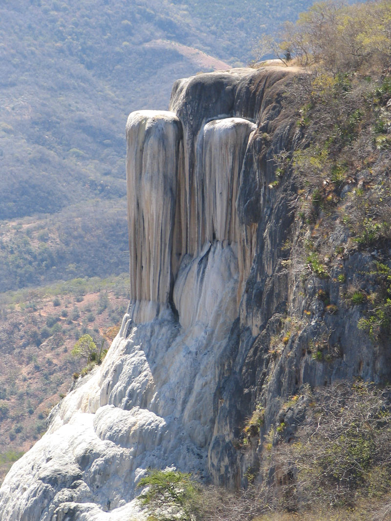
The springs were used in a Zapotec irrigation system dating back to around 1300 B.C. The water has a high calcium carbonate and magnesium content that has resulted in the heavy deposits seen in the photo at right. The water bubbles with escaping air giving the appearance that it is boiling. It is actually a warm spring with a temperature in the 71-77°F range. You can go for a swim in the pools.

There are cabins at the site for overnight stays and a few small restaurants. A nearby mezcal distillery may be visited. Local crafts include items made from palm leaves.

A trail leads down to the base of the feature shown at right and takes 40 minutes to an hour to hike.

The site has experienced some openings and closings due to local disputes over entrance fees among the communities of San Bartolo, San Isidro Roagui, and San Lorenzo Albarradas. The fee is usually 20 pesos.

If traveling from Oaxaca City, some places of interest along the way include El Tule and the small archaeological sites of Dainzú, Lambityeco, and Yagul. The route passes through a mezcal-producing region.

See also Alvin Starkman's article about Hierve el Agua.

More Photos


Calcified waterfall at Hierve el Agua, nearly 100' in height   photo by Linda Bourdage

| Top of page | Main index | Search | What's new |
The Pacific Coast of Mexico www.tomzap.com Tom Penick:   tom@tomzap.com