Home >> Oaxaca >> Oaxaca, Oaxaca >> Weather

Oaxaca Climate and Weather

Clima y Tiempo Atmosférico de Oaxaca

Hyperlink information can change from time to time leaving links non-functional and images either missing or out of date. Please report problems on this page to tom@tomzap.com.
Main Index
Stormy Weather
Colima Weather
Jalisco Weather
Manzanillo Weather
Huatulco Aviation Weather
Oaxaca Aviation Weather
Earthquakes
Hurricane Lester 1998
Hurricane Pauline 1997
Mosquitoes
  Huatulco, Oaxaca
Pinotepa Nacional, Oaxaca
Puerto Angel, Oaxaca
Puerto Escondido, Oaxaca
Zipolite, Oaxaca
Flight to Puerto Escondido 2009
Flight to Puerto Escondido 2014
Flight to Huatulco
Visitors' Comments
AboutHomeSearch
What's New?

Satellite Images | Tropical Storms | Radar Image | High and Low Temperatures | Aviation | Forecast | Seawater Temperatures | Average Rain & Temp Data

The coast of Oaxaca lies well within the tropics at a latitude of about 16°. Monthly lows and highs are typically 18° C (64° F) and 45° C (113° F), averaging 30° C (86° F), with little variation from month to month. The region is generally arid along the coast with more rainfall in the nearby mountains. Most guidebooks say that the rainy season runs from May to October, but in recent years, the length of the rainy season has declined so that July to October is more accurate. September is usually the rainiest month. Amounts vary from year to year and most of the rainfall occurs on a relatively few days. Just because it is the rainy season does not mean it will be raining though; it just means it can rain. A typical day in the rainy season would be a clear morning, clouding up in the afternoon, with thunder heard in the nearby mountains. In this hot climate, the afternoon clouds can be quite welcome.

View this series of photos that illustrate the Seasonal Change in Huatulco from dry season to rainy season.

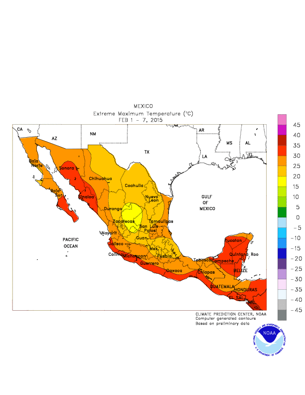
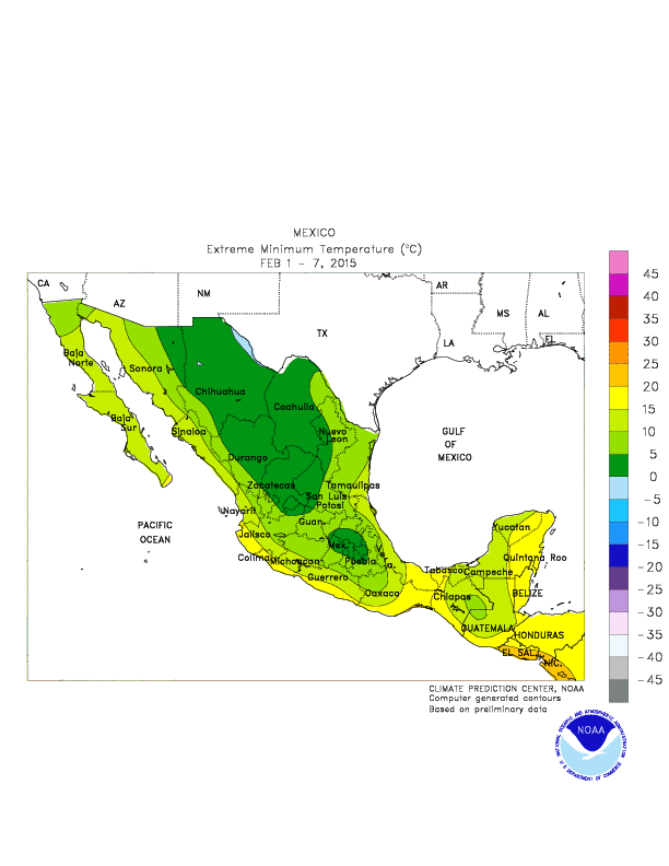
The rainy season is also hurricane season, and hurricanes offshore can have a strong impact on the amount of rainfall. Refer to the satellite, radar, and storm map images below.

November through April is the dry season. As things dry out, most plants (that are not watered) in the lower elevations lose their leaves, but the bougainvillea, which grows wild, takes this opportunity to bloom, and star fruit trees produce their fruit. The terrain is hilly along the coast with granite outcroppings extending into the sea against the backdrop of the Sierra Madre del Sur to the north. Venturing into the mountains, you will soon find yourself in the jungle with a corresponding drop in temperatures as the elevation increases. In the dry season when things are pretty brown on the coast, mountain areas may still be green due to rainfall at the higher elevations. The change in elevation permits a wide diversity of crops including coffee in the moderate elevations and mushrooms in the high elevations.

Fog is extremely rare on the coast of Oaxaca, but has occurred. See photos.


Top of page | Satellite Images | Tropical Storms | Radar Image | High and Low Temperatures | Aviation | Forecast | Seawater Temperatures | Average Rain & Temp Data

Satellite Image from Weather Underground.


Another Satellite Image from Intellicast.


Another image from University of Hawaii.


Top of page | Satellite Images | Tropical Storms | Radar Image | High and Low Temperatures | Aviation | Forecast | Seawater Temperatures | Average Rain & Temp Data

Tropical Storm Information


Top of page | Satellite Images | Tropical Storms | Radar Image | High and Low Temperatures | Aviation | Forecast | Seawater Temperatures | Average Rain & Temp Data

Current Radar Image (if it's working... check the date and time that appears on the image) Puerto Angel
from Servicio Meteorológico Nacional:   Current Greenwich Time GMT

More Radar Images:


Tampico, Tamaulipas


Just south of Veracruz


Top of page | Satellite Images | Tropical Storms | Radar Image | High and Low Temperatures | Aviation | Forecast | Seawater Temperatures | Average Rain & Temp Data

High and Low Temperatures from NOAA

Temperature Conversion Chart


Top of page | Satellite Images | Tropical Storms | Radar Image | High and Low Temperatures | Aviation | Forecast | Seawater Temperatures | Average Rain & Temp Data

Aviation Weather


Top of page | Satellite Images | Tropical Storms | Radar Image | High and Low Temperatures | Aviation | Forecast | Seawater Temperatures | Average Rain & Temp Data

10-day Weather Forecasts


Top of page | Satellite Images | Tropical Storms | Radar Image | High and Low Temperatures | Aviation | Forecast | Seawater Temperatures | Average Rain & Temp Data

Seawater Surface Temperatures   from NOAA


Top of page | Satellite Images | Tropical Storms | Radar Image | High and Low Temperatures | Aviation | Forecast | Seawater Temperatures | Average Rain & Temp Data

Some historical rainfall and temperature data for Puerto Angel:

Puerto Angel (1931 - 1940)
JanFebMarAprMayJun JulAugSepOctNovDecAnnual
Rain (mm.)   1  8  0  0104207 157206452118  7  81268
Rain (in.)   00.3  0  04.18.1 6.28.1184.60.30.3    50
# of rainy days   0  0  0  0  2  9   9  811  4  0  0    43

Puerto Angel (1945 - 1948)
JanFebMarAprMayJun JulAugSepOctNovDecAnnual
Rain (mm.)   0  0  0  078112 993720665  0  0  597
Rain (in.)   0  0  0  03.14.4 3.91.58.12.6  0  0    23
# of rainy days   0  0  0  0  4  5   3  3  7  2  0  0    24
Temperature (C) 303030313230 313030302929    30
Temperature (F) 868686889086 888686868484    86

Puerto Angel weather conditions (link) from the Weather Underground.
Photo of Puerto Angel during the rainy season.


This page has been visited times since April 4, 2010.
| Top of page | Main index | Search | What's new |
The Pacific Coast of Mexico www.tomzap.com Tom Penick:  tom@tomzap.com